You can see more about this trip here.
Day 1:
Mauvoisin - Cabane Chanrion
Your journey starts in Mauvoisin with a climb to the top of the Mauvoisin Dam, one of the highest arch dams in Europe. From here, enjoy sweeping views of Lac de Mauvoisin, a turquoise lake stretching nearly 5 kilometers. Crossing the dam to the right bank, follow a trail through a series of tunnels, with waterfalls tumbling down the cliffs around you.
The route continues on a well-marked path to the Écuries du Giétro, a group of historic mountain buildings. Beyond this, the trail opens onto the Tsofeirë plateau, a peaceful area of alpine meadows. A steady climb leads to the Tsofeirë Pass, where you’ll get stunning views of the surrounding peaks and glaciers.
From the pass, descend through rugged terrain shaped by glaciers, eventually reaching the Cabane de Chanrion, your final stop for the day. This welcoming mountain hut provides a well-earned rest after a rewarding day of hiking through varied and dramatic landscapes.
11kms / 900m up / 300m down / 4 hours
Day 2:
Cabane Chanrion - Rifugio Champillon
From the Cabane de Chanrion, the route is visible as it descends through rolling alpine pastures toward the Grand Charmotane Bridge. After crossing the bridge, the trail steepens for a short while before easing into a mix of rocky and grassy terrain. A well-marked path then leads up to the Fenêtre de Durand, a high mountain pass steeped in history. It was here in 1943 that Luigi Einaudi, later the second president of Italy, crossed into Switzerland while fleeing fascism, welcomed by Swiss soldiers.
From the Fenêtre de Durand, the descent toward By offers striking views of the imposing Mont Gelé and the gentler slopes of Mont Avril, marking the transition between the Valais and the Aosta Valley. The trail first navigates rocky terrain before reaching the Thoules pastures, where it joins a forestry road leading toward the Balme pasture and the By Basin. From there, a short 150-meter ascent brings you to the Ru de By, which you follow until reaching Néan. Leaving the watercourse behind, the final climb leads to Tsa de Champillon, before arriving at the Rifugio Champillon, your stop for the night.
23kms / 1200m up / 1100m down / 8 hours
Day 3:
Rifugio Champillon - St. Rhemy
Leaving the Rifugio in Champillon, the trail climbs steeply toward the Champillon Col, where you’ll be rewarded with sweeping views of the Grand Combin and the Mont Blanc massif in the distance. From the pass, the descent leads into the Menouve Valley, passing through the Pointier pasture before the route begins to climb again.
Following the Tour des Combins, the trail ascends to the Combe Germain pasture before reaching the Eternod Stream. From here, the route heads west through a scenic larch forest, eventually meeting the Barasson mountain. A final stretch on a well-marked path connects to a forestry road, leading down to Saint-Rhémy, marking the end of the day’s hike.
15kms / 500m up / 1200m down / 5 hours
Day 4:
St. Rhemy - Rifugio Frassati
Today it's all ascent to the Rifugio Frassati - have a leisurely lie in and breakfast this morning - no need to leave at the crack of dawn. The day is quite manageable (and at Rifugio Frassati check in to the rooms is not until 4pm).
From Saint-Rhémy-en-Bosses, the ascent begins into the Comba de Merdeux, passing the Alpe Merduex Infereriore at 1950m. Here there are a few buildings and a water fountain - which makes for a great rest stop.
The trail steadily climbs contouring the mountain, from here Rifugio Frassati comes into view - standing majestic up the distance. Onwards and upwards past the dairy farm of Alpeggio Tsa de Merdeux, an alpine dairy farm at about 2 273 m. It’s the last significant group of summer mountain huts (baite) used for grazing cows and cheese production, including regional Fontina cheese from high-altitude milk. The trail continues up to the Rifugio Pier Giorgio Frassati, a welcoming mountain hut and your destination for the night.
9kms / 1000m up / 100m down / 4 hours
Day 5:
Rifugio Frassati - Great St. Bernard Pass
Leaving the Frassati Refuge, the trail heads northeast toward the Col des Ceingles at 2,817 meters. The trail starts out mellow leaving the refuge, until you arrive at a saddle where it steeply ascends up to the Col.
From the Col, a descent leads into the Comba des Thoules the immediate descent after the Col is steep underfoot loose rocks, take care. Quickly the path levels out opening up splendid views down the valley - watch out for marmottes this is a hot spot for them!
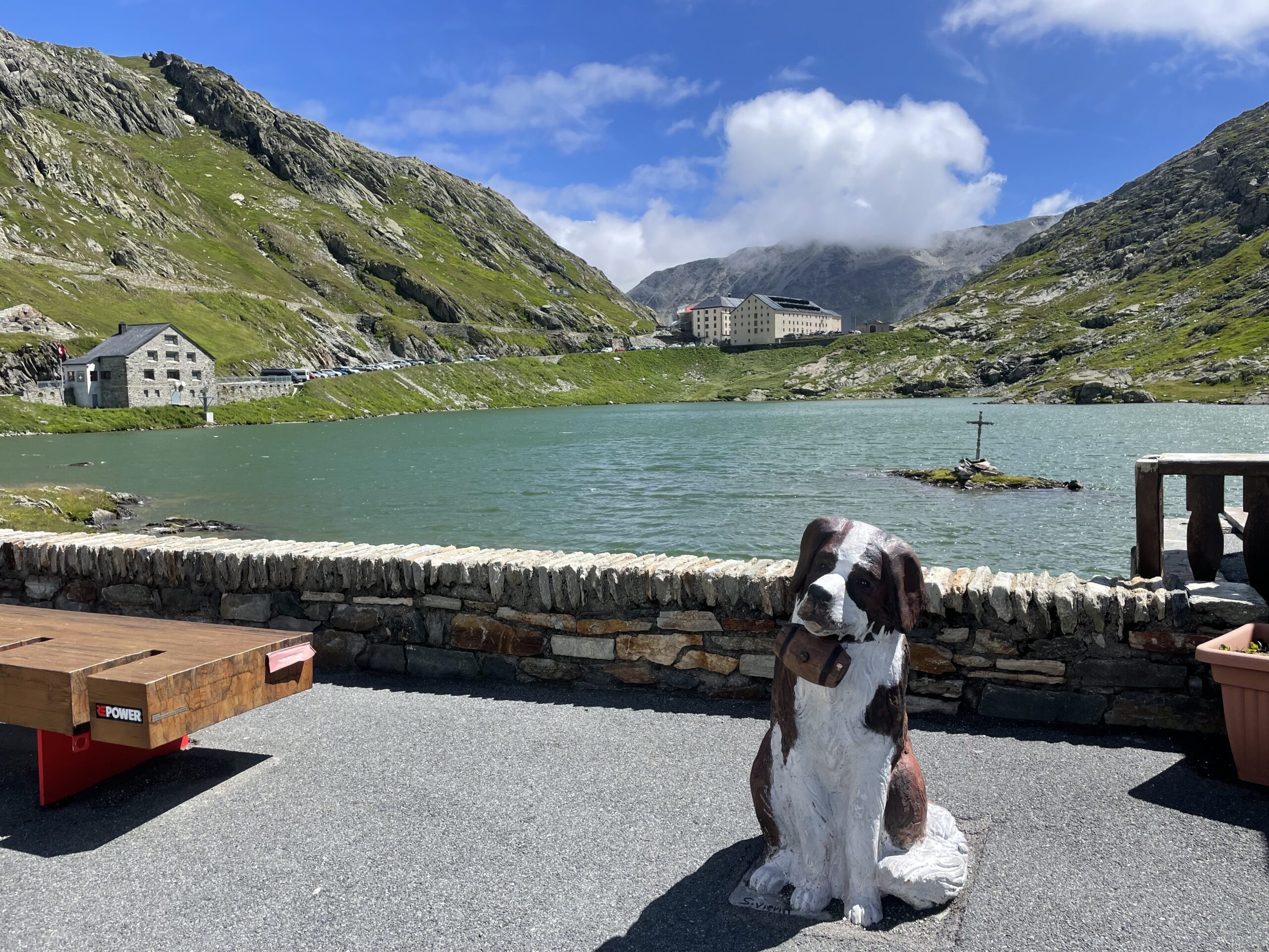
Once arriving at the Col de Saint-Rhémy at 2,563 meters, you are able to see over to the Grand Saint Bernard pass and the road winding up to the pass. The trail then continues downhill, passing through Praz de Farcoz before a short and slightly steep section contouring the mountain. The trail then continues down to join the Route du Grand-Saint-Bernard above Fonteinte.
A final uphill stretch leads to the Col du Grand-Saint-Bernard, home to the historic hospice and its famous St. Bernard dogs, marking the end of today's trek.
10kms / 700m up / 800m down / 4 hours
Day 6:
Great St. Bernard Pass - La Fouly
Today you have two options:
Option 1: Fenetre du Ferret - Lacs de Fenetre - La Fouly
Option 2: Col des Chevaux variant - Lacs de Fenetre - La Fouly (Highly recommended if good weather)
Option 1: Starting at the historic Great St. Bernard Hospice at 2,470 meters, you the route begins with a descent past Lac du Saint Bernard. Crossing the border back into Italy, the trail leads down to the Baou mountain pasture before beginning a steady climb toward the Fenêtre de Ferret, the pass marking the Italian-Swiss border. From the pass, a gentle descent brings you to the Lacs de Fenêtre, with breathtaking vistas of Mont Blanc, Grandes Jorasses, and Mont Dolent in the distance.
Option 2: (not recommended in bad weather conditions)
The path climbs gently at first, passing grassy slopes and scattered boulders. Keep your eyes open—marmots and ibex are often spotted here. After about 30–40 minutes, you'll begin the steeper ascent to the Pas des Chevaux. This stretch is a bit rocky and narrow in places, so take your time and watch your footing—especially if it's damp or there's lingering snow. “Pas des Chevaux” means “Pass of the Horses,” but today it’s more for nimble hikers rather than hoofed travel. Once you reach the pass, take in the sweeping views of the Mont Blanc. Then descend carefully down the opposite side, following the path as it winds through rocky sections. After about another 30–40 minutes, you’ll arrive at the stunning Lacs de Fenêtre, by crossing over the Col du Bastillon 2754m - the ascent to and from the Col is steep take care.
From the Lacs du Fenetre to La Fouly:
The trail then drops more steeply past the Plan-La-Chaux and Ars mountain pastures, eventually reaching the hamlet of Ferret. Following the Dranse River, the path alternates between its left and right banks before arriving in La Fouly, the endpoint for the day.
Option 1: 13kms / 400m up / 1200m down / 4 hours
Option 2: 15kms / 900 m up / 1700 m down / 6 hours
Day 7:
La Fouly - Cabane La Tsissette
The day’s hike begins with a climb to the Col du Basset, a 1,200-meter ascent that can be shortened by taking the Arpalle chairlift which will save 400m of elevation. From the top of the lift, follow signs for the Col du Basset, crossing the Alpage de la Fouly before the trail steepens and winds toward the pass. Along the way, you may spot chamois, ibex, and marmots, while the panoramic views make the effort worthwhile.
From the Col du Basset, the descent leads into the Combe de l’A, a protected nature reserve in the Grand-Saint-Bernard region. Spanning elevations from 1,400 to 3,000 meters, this area is rich in wildlife - keep your eyes peeled it's a marmotte hot spot!
Following the Ruisseau de l’A, the route eventually reaches the Cabane La Tsissette, offering food and accommodation from mid-June to mid-October. Nestled in a peaceful setting, it provides a perfect resting spot for the night.
11.5kms / 1100m up / 700m down / 5 hours
Day 8:
Cabane La Tsissette - Cabane Mille
Today you have two options:
Option 1: via Liddes - Recommended *Leaves you a bit of juice left in the tank if you'd like to summit Mont Brule after arriving at the Cabane (100m up and 100m down from the Cabane).
Option 2: via Bourg St Pierre
Leaving La Tsissette, the trail heads down towards the valley floor, exiting the Combe de l’A and descending toward the village of Drance, situated along the River Dranse.
Option 1:
From here, a steady descent leads to Liddes. Once in Liddes follow the signs for Sentier des Éperviers and Cabane Col de Mille. The trail climbs steeply to Erra d'en Bas - with a view point marked with a large wooden cross looking back down at Liddes and across to the Mont Blanc Massif. Another 1.5 hours to go from here to the Cabane. You will push up to the Alpage - working dairy farm at Erra d'en Haut (2265m) before turning left towards the Cabane - which you can see perched on the Col.
Option 2:
The route turns south into the Grand-Saint-Bernard Valley, gradually ascending to Bourg-Saint-Pierre. As the most significant village on the Grand Tour des Combins, Bourg-Saint-Pierre is rich in history, featuring landmarks such as the Saint-Charles Bridge, an ancient bell tower, a Roman milestone, and well-preserved historic homes. After exploring the village, the trail continues upward, passing the Chapel of Lorette, Creux du Mâ, Boveire d’en Bas, Le Coeur, and Erra, meandering through alpine pastures with stunning views over the Entremont Valley and the Mont Blanc Massif.
The day's journey ends at the Col de Mille, where the Col de Mille Hut, a cozy 59-bed mountain refuge, offers breathtaking panoramic views and a well-deserved rest.
Option 1: 13kms / 1200m up / 800m down / 5 hours
Option 2: 24kms / 1400m up / 900m down / 8 hours
Day 9:
Cabane Mille - Panossiere Hut
Today you have two options:
Option 1: via La Maye
Option 2: via Col des Avouillons variant (Highly recommended in good weather)
From the Col de Mille, the trail enters the Bagnes municipality, Switzerland’s largest at 282 km². The route gradually turns northeast, with epic views of Verbier - a stunning balcony trail (one of our favourite sections of the hike). The trail runs down a narrow saddle where from here, you'll enjoy sweeping views over the scattered hamlets of Bagnes, home to around 7,800 residents. You will cross though the dairy farm at the Lake Goli de Servay, there are cows on and around the trail - requiring you to open and close electric fences behind you.
Continuing east, the path winds through Arolla pines and myrtille (blueberries in French - although slightly smaller and more bitter) bushes before arriving at the Brunet Hut. This makes for an excellent lunch or rest stop. They serve food and drinks - there is also the possibility to take a shuttle bus down or walk down to the valley from here if you need to exit the hike early. Details/Timetables on the Bus Stop POI next to the Hut.
From Brunet, the route heads southeast on another balcony trail sweeping around the mountain leading to the Sery Bridge, which spans over a narrow gorge. Here is where you have the choice:
Option 1: via La Maye
Cross the bridge and follow the trail signed La Maye after a mix of gentle climbs and descents, you will arrive at a very steep zigzagging ascent which brings you to the famous 200-meter-long passerelle, crossing streams fed by the Corbassière Glacier. From here the landscape changes drastically to high alpine scenery, the trail is rockier on these sections.
Option 2: via Col des Avouillons variant (not recommended in bad weather).
From the junction at Sery Bridge carry on straight via Col des Avouillons. The approach to Col des Avouillons steepens over loose scree and rocky ground, with occasional snow patches early in the season. The final section to the col (2,646 m) is short but steep, opening onto views of the Corbassière Glacier and the Grand Combin. From the col, the trail descends on a zigzag path down a rubbly slope to the glacier’s lateral moraine. The surface can be unstable, so careful footing is needed.
Both trails then join before the Passerelle a 210m long and 70m high bridge crossing the Dyure de Corbassière. A head for heights is required.. but the bridge must be crossed - so don't look down if thats you! If you are slightly nervous too - wait until the bridge is empty before crossing as other people can make a bit of movement to the bridge!
From here, a final uphill ascent to the François-Xavier Bagnoud Hut in Panossière, where breathtaking glacier views and a well-earned rest await.
Top tip: Watch out for Edelweiss, there is a lot in this area!
Option 1: 14.5 kms / 800 m up / 600 m down / 5 hours
Option 2: 15 kms / 1500 m up / 1300 m down / 7 hours
Day 10
Panossiere Hut - Mauvoisin
After passing along the moraine on the right bank of the Corbassière glacier, you'll start a short but steep climb up to the Col des Otanes, standing at 2870m, the highest point of the GTDC. The upper section is on a clear but rocky path, with some loose gravel and occasional snow patches early in the season. The climb is steep but not technical, though the pass is fully exposed to the wind and weather, with little shelter. From here, the view is truly breathtaking. Surrounded by towering rock and ice, the Grand-Combin stands tall, offering a view of one of the most stunning spots in the Alps.
A one-hour descent brings you to Tseumette. From this grassy saddle, you'll have a great view of the Mont-Pleureur and Ruinette peaks. Far below, you can spot the impressive 250m-high concrete wall of Europe’s tallest arch dam. The descent continues all the way to Mauvoisin. Take your time - the descent can be brutal on your knees!
7 kms / 300 m up / 1000m down
