You can see more about this trip here.
Day 1:
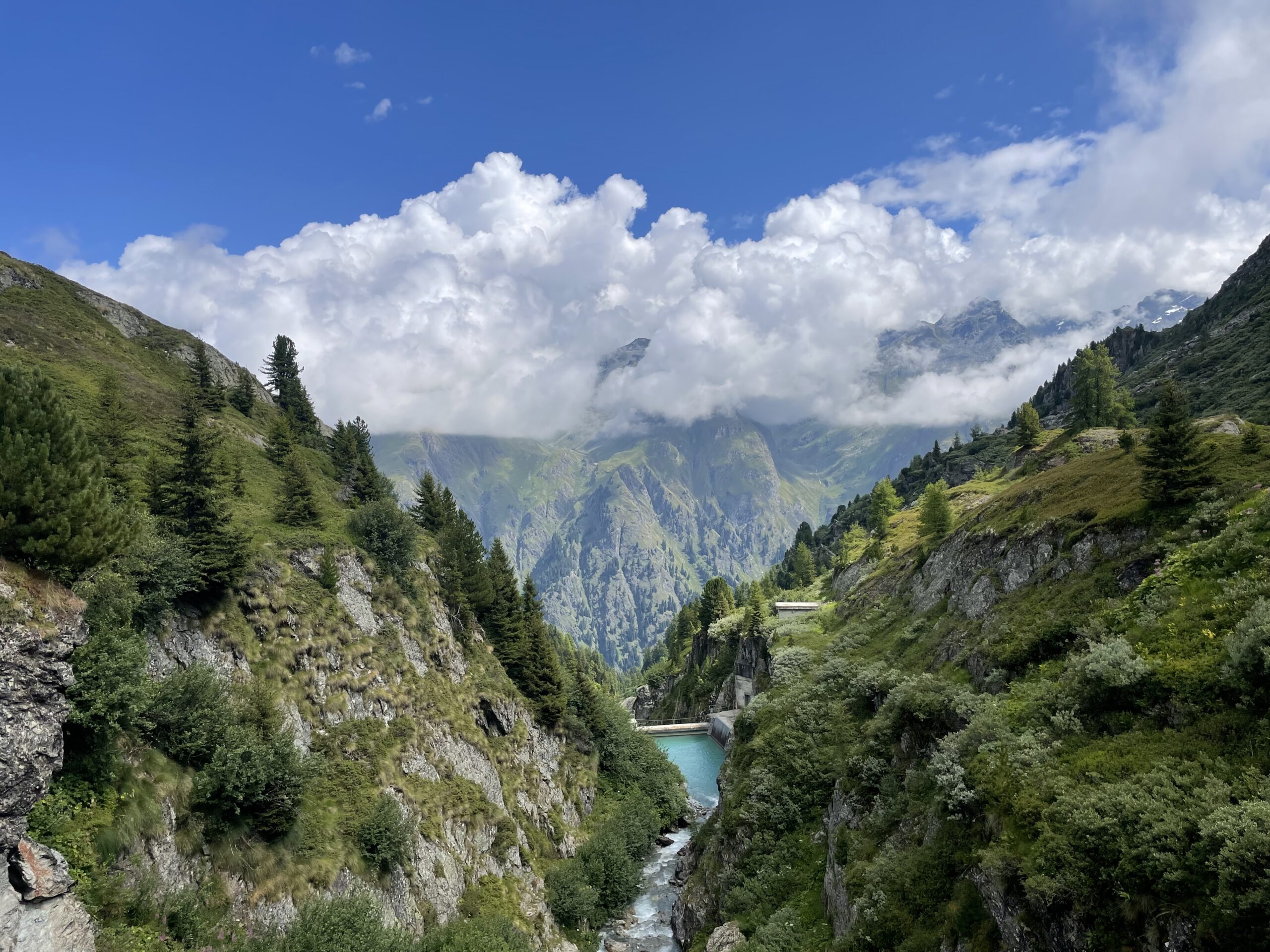
Mauvoisin - Cabane Chanrion
Your journey starts in Mauvoisin with a climb to the top of the Mauvoisin Dam, one of the highest arch dams in Europe. From here, enjoy sweeping views of Lac de Mauvoisin, a turquoise lake stretching nearly 5 kilometers. Crossing the dam to the right bank, follow a trail through a series of tunnels, with waterfalls tumbling down the cliffs around you.
The route continues on a well-marked path to the Écuries du Giétro, a group of historic mountain buildings. Beyond this, the trail opens onto the Tsofeirë plateau, a peaceful area of alpine meadows. A steady climb leads to the Tsofeirë Pass, where you’ll get stunning views of the surrounding peaks and glaciers.
From the pass, descend through rugged terrain shaped by glaciers, eventually reaching the Cabane de Chanrion, your final stop for the day. This welcoming mountain hut provides a well-earned rest after a rewarding day of hiking through varied and dramatic landscapes.
11km / 900m up / 282m down / 4 hours
Day 2:
Cabane Chanrion - Rifugio Champillon
From the Cabane de Chanrion, the route is visible as it descends through rolling alpine pastures toward the Grand Charmotane Bridge. After crossing the bridge, the trail steepens for a short while before easing into a mix of rocky and grassy terrain. A well-marked path then leads up to the Fenêtre de Durand, a high mountain pass steeped in history. It was here in 1943 that Luigi Einaudi, later the second president of Italy, crossed into Switzerland while fleeing fascism, welcomed by Swiss soldiers.
From the Fenêtre de Durand, the descent toward By offers striking views of the imposing Mont Gelé and the gentler slopes of Mont Avril, marking the transition between the Valais and the Aosta Valley. The trail first navigates rocky terrain before reaching the Thoules pastures, where it joins a forestry road leading toward the Balme pasture and the By Basin. From there, a short 150-meter ascent brings you to the Ru de By, which you follow until reaching Néan. Leaving the watercourse behind, the final climb leads to Tsa de Champillon, before arriving at the Rifugio Champillon, your stop for the night.
23km / 1135m up / 1170m down / 8 hours
Day 3:
Rifugio Champillon - St. Rhemy
Leaving the Rifugio in Champillon, the trail climbs steeply toward the Champillon Col, where you’ll be rewarded with sweeping views of the Grand Combin and the Mont Blanc massif in the distance. From the pass, the descent leads into the Menouve Valley, passing through the Pointier pasture before the route begins to climb again.
Following the Tour des Combins, the trail ascends to the Combe Germain pasture before reaching the Eternod Stream. From here, the route heads west through a scenic larch forest, eventually meeting the Barasson mountain. A final stretch on a well-marked path connects to a forestry road, leading down to Saint-Rhémy, marking the end of the day’s hike.
15km / 464m up / 1135m down / 5 hours
Day 4:
St. Rhemy - Great St. Bernard Pass
Starting in Saint-Rhémy, the trail first leads to the main village of Saint-Léonard, passing through its center and continuing westward beyond the church. After crossing beneath the international road, the route follows a path under the covered road leading back toward the Crévacol ski area.
From here, the ascent begins into the Comba de Merdeux, winding through alpine terrain and passing several mountain pastures along the way. The trail steadily climbs until reaching the Rifugio Pier Giorgio Frassati.
Leaving the Frassati Refuge, the trail heads northeast toward the Col des Ceingles at 2,817 meters. From the pass, a descent leads into the Comba des Thoules, followed by a short climb to the Col de Saint-Rhémy at 2,563 meters.
The path then winds downhill, passing through Praz de Farcoz before joining the Route du Grand-Saint-Bernard above Fonteinte. A final stretch leads to the Col du Grand-Saint-Bernard, home to the historic hospice and its famous St. Bernard dogs, marking the end of today's trek.
21km / 1881m up / 1039m down / 8 hours
Day 5:
Great St. Bernard Pass - Cabane La Tsissette
Starting at the historic Great St. Bernard Hospice at 2,470 meters, the route begins with a descent past the scenic Lac du Saint Bernard, with the Italian mountains reflecting in its waters. Crossing the border back into Italy, the trail leads down to the Baou mountain pasture before beginning a steady climb toward the Fenêtre de Ferret, the pass marking the Italian-Swiss border, where stunning panoramic views await.
From the pass, a gentle descent brings you to the Lacs de Fenêtre, with breathtaking vistas of Mont Blanc, Grandes Jorasses, and Mont Dolent in the distance.
The variant offers a quieter path cutting out the town of La Foult, perfect for those seeking solitude and a deeper connection with nature. You'll pass by pristine mountain lakes reflecting the surrounding peaks, providing ideal spots to rest and take in the serene beauty.
Approaching Cabane La Tsissette, nestled amidst towering peaks, you'll be greeted with warm hospitality and hearty alpine cuisine. Spend the evening soaking in the tranquility, with the Milky Way painting the night sky above.
12.6km / 814m up / 1285m down / 6 hours
Day 6:
Cabane La Tsissette - Cabane Mille
Leaving La Tsissette, the trail heads north, exiting the Combe de l’A and descending toward the village of Drance, situated along the River Dranse. From here, a steady climb leads to Liddes, the main village of the region, before the route turns south into the Grand-Saint-Bernard Valley, gradually ascending to Bourg-Saint-Pierre.
As the most significant village on the Grand Tour des Combins, Bourg-Saint-Pierre is rich in history, featuring landmarks such as the Saint-Charles Bridge, an ancient bell tower, a Roman milestone, and well-preserved historic homes. After exploring the village, the trail continues upward, passing the Chapel of Lorette, Creux du Mâ, Boveire d’en Bas, Le Coeur, and Erra, meandering through alpine pastures with stunning views over the Entremont Valley.
The day's journey ends at the Col de Mille, where the Col de Mille Hut, a cozy 59-bed mountain refuge, offers breathtaking panoramic views and a well-deserved rest.
24km / 1560m up / 1113m down / 8 hours
Day 7:
Cabane Mille - Mauvoisin
From the Col de Mille, the trail enters the Bagnes municipality, Switzerland’s largest at 282 km². The Tour des Combins route gradually turns northeast, reaching La Treutse (2,092m) after about an hour. From here, you'll enjoy sweeping views over the scattered hamlets of Bagnes, home to around 7,800 residents.
Continuing east, the path winds through Arolla pines and blueberry fields before arriving at the Brunet Hut. From there, the route heads southeast, leading to the Sery Bridge, which spans a narrow gorge. After a mix of gentle climbs and descents, the trail reaches the small village of La Maye.
A steep zigzagging ascent brings you to a 200-meter-long footbridge, crossing streams fed by the Corbassière Glacier. From here, an easy final stretch leads to the François-Xavier Bagnoud Hut in Panossière, where breathtaking glacier views and a well-earned rest await.After passing along the moraine on the right bank of the Corbassière glacier, you'll start a short but steep climb up to the Col des Otanes, standing at 2870m, the highest point of the TDC. From here, the view is truly breathtaking. Surrounded by towering rock and ice, the Grand-Combin stands tall, offering a view of one of the most stunning spots in the Alps.
A one-hour descent brings you to Tseumette. From this grassy saddle, you'll have a great view of the Mont-Pleureur and Ruinette peaks. Far below, you can spot the impressive 250m-high concrete wall of Europe’s tallest arch dam. The descent continues all the way to Mauvoisin.
22kms / 1353m up / 1977m down / 9 hours
